

During February-March 2025, a seismic swarm occurred near the Santorini-Anydros-Amorgos area, with thousands of earthquakes being recorded with a maximum magnitude of M5.2. Hundreds of earthquakes with magnitudes larger than 3 were recorded and felt by inhabitants of Santorini and neighboring islands, to a tentative self-evacuation of Santorini and the declaration of emergency state by the Hellenic government.
In light of these events, we rapidly responded to the ongoing crisis by designing and deploying a new seismic array in Santorini (SantoArray). The collaboration between the Aristotle University of Thessaloniki (Greece) and the Institute of Geophysics, Polish Academy of Sciences (Poland) facilitated the preparation, shipment, deployment, maintenance, and data analysis of 7 SmartSolo units and 117 DATA-CUBE instruments. The network operated continuously for approximately 3 weeks (28 February – 23 March 2025) without instrumentation losses, resulting in a plethora of data recorded by the deployed large-N network.
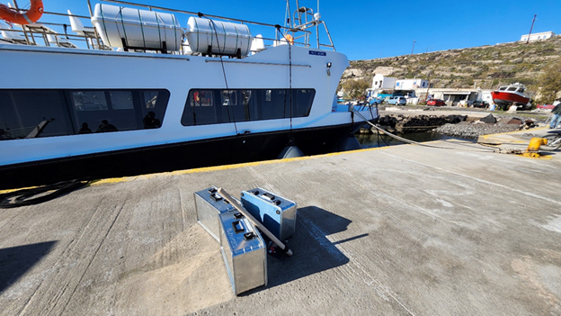
Fieldwork for the new hybrid temporary network (SantoArray) was accomplished by 3 total visits in the island. 3 teams of 2 personnel each worked for about 2 days. The contribution of private companies and local volunteers was instrumental to the success of the experiment. The first visit was to initially deploy the instruments, the second to change the batteries and relocate stations and the third to wrap the experiment. Stations were mostly deployed in rural areas and barely buried to minimize disturbance and still retrieve GPS signal.
The SantoArray project comprises of continuous records from all seismic permanent (broadband and wideband; red squares in Fig. 1) stations in Santorini operating under the Hellenic Unified Seismic Network (H.U.S.N.), augmented with temporarily deployed nodal stations (117 DATA-CUBE 3-C and 7 SmartSolo 3-C instruments) in two deployment phases (I and II), with distinct instrument configurations and geometries. Phase I (28 February – 11 March, Fig. 1a) involved the installation of 7 SmartSolo 5Hz IGU-16HR-3C sensors (blue triangles in Fig. 1a) and 117 DATA-CUBE digitizers equipped with 4.5 Hz 3-component sensors, set in two different instrument gain configurations (minimum-“low” and maximum-“high” possible) deployed as follows: 50 co-located low- and high-gain sensor sites (grey triangles in Fig. 1a), 10 high-gain sensors (white triangles in Fig. 1a) and 7 low-gain sensors (black triangles in Fig. 1a), with a ~1.3 km average inter-station spacing. Phase II (11-23 March; Fig. 1b) was initiated due to instrument battery replacing needs and comprises of the same total instrument number. However, during Phase II we have set all sensors configuration to the maximum possible gain (white triangles in Fig. 1b), while sensors co-located at “double” (low- and high-gain) sites and near permanent station locations (grey and several black triangles of Fig. 1a) were relocated and distributed throughout Santorini to improve the inter-station spacing to about ~600m. Finally, we successfully retrieved all stations and downloaded above 95% of the expected continuous time series for future analyses.
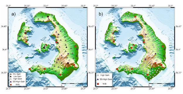
Fig. 1. Sensor distribution of the newly deployed SantoArray temporary network. Red squares show permanent Wide- band and Broadband stations from the Hellenic Unified Seismic Network. Blue triangles show deployment locations of the 7 SmartSolo sensors and otherwise colored triangles show the 117 DATA-CUBE sensors. a) SantoArray Phase I, b) SantoArray Phase II.